Welcome, Guest
Username: Password: Remember me

TOPIC: 3D map on HDS ?

3D map on HDS ? 10 years 11 months ago #3874

  • fjordfisher
  • fjordfisher's Avatar
  • Offline
Yes, the result is optical very good. What a source of DEM You use - it's a free source?
Last Edit: 10 years 11 months ago by fjordfisher.
The administrator has disabled public write access.

3D map on HDS ? 10 years 11 months ago #3875

  • fvignola
  • fvignola's Avatar
  • Offline
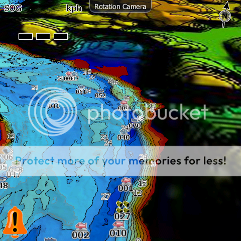
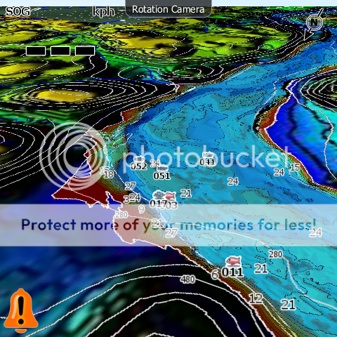
The source is my HDS 8 ;)

I have over 200gb of data recorded since the last 3 years... (Two River and 3-4 Lakes)

This river is 38 miles long, with 2-3km width at some place... I have about 80% of it :) At the end of the Hunting season, I should be near 90-95%... When Hunting, I log data where I don't log while fishing (because of the depth)...
Last Edit: 10 years 11 months ago by fvignola.
The administrator has disabled public write access.

3D map on HDS ? 10 years 11 months ago #3877

  • fjordfisher
  • fjordfisher's Avatar
  • Offline
If You use GM, why You don't use an GM aerial background. GM has good free sources and the advantage is, that You can create geotiff's with high resolution - try >= 600 dpi without compression. This give good results in the IMC raster.
Last Edit: 10 years 11 months ago by fjordfisher.
The administrator has disabled public write access.

3D map on HDS ? 10 years 11 months ago #3882

  • fvignola
  • fvignola's Avatar
  • Offline
That's interresting fjordfisher... Include imagery and other data is my next step...

I'm currently processing image from elevation data combined with imagery... (Look 3D too)... Very long to process...

But when you speak about 600 dpi geotiff, I'm not sure how to do it ??? Where you set de resolution to 600 dpi ? The only resolution I see when exporting from globalmapper is the jpg quality, and I don't know what this number represent... Default is 75 I think... ?

If you could elaborate a little more on how to do it, I'll be good to go...

Thanks

Fred
The administrator has disabled public write access.

3D map on HDS ? 10 years 11 months ago #3883

  • fvignola
  • fvignola's Avatar
  • Offline
Always better and better...

Last Edit: 10 years 11 months ago by fvignola.
The administrator has disabled public write access.

3D map on HDS ? 10 years 11 months ago #3884

  • fjordfisher
  • fjordfisher's Avatar
  • Offline
Use e. g. "world imagery" as aerial background source.

File >>> Download Online Imagery/ ...>>> World Imagery >>> Connect


Export

File >>> Export >>> Export Raster/Image Format >>> GeoTIFF

As i correct remember, use the min settings in the pic. More settings try self ...

Don't forget the correct coordinate system!


For good zoom quality i use a lot of pictures from different zoom levels, min 300 dpi for highest sight height and as much as possible in deepest sight height (>= 600 dpi).
Last Edit: 10 years 11 months ago by fjordfisher.
The administrator has disabled public write access.

3D map on HDS ? 10 years 11 months ago #3885

  • Matt
  • Matt's Avatar
  • Offline
Looks nice Fred, and it could be an interesting idea for a ReefMaster feature.

I just played around with a screen-shot from the RM 3D view as a raster background, and exported a project with only contours (no isobaths - all colour is in the raster).

Looks OK! (contours slightly misaligned as the raster background was only roughly calibrated..). Only a gen 1, so no 2.5D rotate.

Last Edit: 10 years 11 months ago by Matt.
The administrator has disabled public write access.

3D map on HDS ? 10 years 11 months ago #3886

  • fjordfisher
  • fjordfisher's Avatar
  • Offline
Yes Matt, this is a good idea for RM and a olive-green background is much better as in black color and mostly sufficient. I hope, that this solution also works in small & flatt lakes.
The administrator has disabled public write access.

3D map on HDS ? 10 years 11 months ago #3888

  • fvignola
  • fvignola's Avatar
  • Offline
The administrator has disabled public write access.

3D map on HDS ? 10 years 11 months ago #3889

  • fjordfisher
  • fjordfisher's Avatar
  • Offline
Fred,


i believe, that the rotation/3D function in the unit can not work so good as in a horizontal projection, because there is not any all-terrain tread, only a flat picture.


fjordfisher
Last Edit: 10 years 11 months ago by fjordfisher.
The administrator has disabled public write access.

3D map on HDS ? 10 years 11 months ago #3890

  • Matt
  • Matt's Avatar
  • Offline
Thanks for the idea Fred! We'll add Shaded Relief as a raster export option (direct from Projects only) in the next version of RM.

Here's a couple of examples - a special (orthographic) projection of 3D model is used, and exported at a somewhat higher resolution than displayed in RM. Lighting is the from the NW, which is more or less standard for shaded relief images.

Very nice results, and compatible with any unit that supports raster backgrounds - all HDS and Elite HDI. No transparency is required, just line contours on the coloured background:


Last Edit: 10 years 11 months ago by Matt.
The administrator has disabled public write access.

3D map on HDS ? 10 years 10 months ago #3949

  • fvignola
  • fvignola's Avatar
  • Offline
Nice, thanks you Matt, it will be a great feature !!!!!!!!!!!!!!!!!

Next step, I'm planning to do the same thing for my Garmin...
The administrator has disabled public write access.
SCROLL TO TOP