
See what you've been missing
ReefMaster Software offers a suite of affordable, consumer-friendly Windows PC applications to help you get the most out of your sonar. Manage waypoints, trails and routes and view sonar logs from your Lowrance device with our new Waypoint Manager/Sonar Viewer for Lowrance, view sonar logs with our standalone Sonar Viewer, or create 3D bathymetric maps and sidescan mosaics using ReefMaster. ReefMaster is your complete sonar solution - ideal for marine professionals, academics and fishing enthusiasts. Get started with a free trial and experience it for yourself.
Waypoint Manager/Sonar Viewer for Lowrance
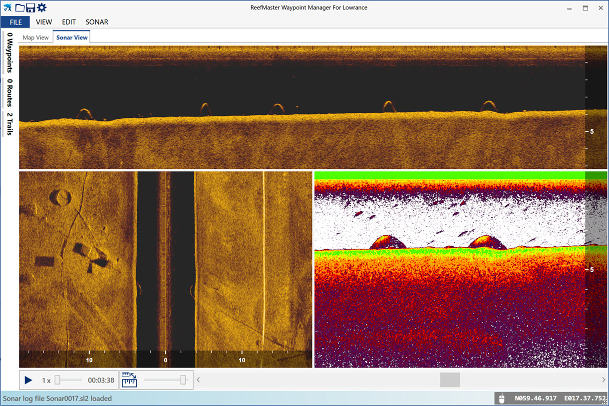
The ReefMaster Waypoint Manager/Sonar Viewer for Lowrance is a Windows application designed specifically to work with data from Lowrance sonar units.
This easy-to-use program includes waypoint, trail and route management along with a multi-channel sonar viewer. Previously tedious tasks, such as updating waypoint icons or labels, or removing duplicate waypoints, can be completed in seconds with a minimum of effort.
- Display, edit and manage waypoints with full equivalent Lowrance icon and colour sets.
- Display, edit and manage routes and trails, convert trails to routes and convert route-points to waypoints.
- Easily select groups of waypoints, trails or routes for export, editing or deletion.
- Group editing operations on waypoints and trails, including icon and colour, label visibility and more.
- Import export of Lowrance USR file format in versions 3/4/5/6, Google Earth, GPX and CSV file formats. Quickly and easily convert one file type to any other.
- Copy and paste trails and waypoints directly from Google Earth.
- Simple to use waypoint duplicate-removal tool.
- Full multi-channel sonar viewer for Lowrance SLG, SL2 and SL3 sonar log files.
- Metric or US units.

Features
Waypoint Management
- View, edit and manage waypoints with full equivalent Lowrance icon and colour sets, and all available Lowrance waypoint attributes, including alarm radius, depth and description.
- Bulk editing of any waypoint attribute. Groups of waypoints can be selected in the map or list views, and waypoints can be sorted by a range of criteria, including symbol, name, time, latitude or longitude.
- Group delete or export of selected waypoints, making it extremely easy to export waypoints from a specified region to a new data file.
- Manage waypoint duplicates with our easy-to-use duplicate removal tool. Remove waypoints with exactly the same locations, or within a specified range, with or without the same name or time of creation.
- Import waypoints from Lowrance USR files, preserving internal Lowrance IDs, or from Google Earth (KML), GPX or text files.
- Copy and paste waypoints directly from Google Earth.


Trail Management
- View and edit Lowrance trails with the full Lowrance colour set.
- Split trails composed of multiple recording segments into individual trails, allowing each to be edited separately.
- Convert trails to routes, with adjustable trail simplification so you can generate routes with just as many route points as you need.
- Bulk editing, delete or export.
- Copy and paste trails directly from Google Earth.


Route Management
- Graphical route editing.
- Create routes by hand or using a list of waypoints.
- Quickly convert trails, or parts of trails, to routes, with adjustable simplification level.
- Convert route points to waypoints, singly or in bulk.


Sonar Viewer
- Multi channel sonar viewer supports Lowrance SLG, SL2 and SL3 sonar file formats.
- View all recorded channels, together or in any combination, with flexible sonar channel layout.
- Take waypoints in 2D or sidescan channel views.
- Fast playback up to 30x speed.
- View sonar side-by-side with map view, or in a full window.
- Take high resolution image snapshots to the clipboard.
- Measure distance in any channel view and or estimate object height in the sidescan channel view.
- A range of 2D and sidescan colour palettes, with adjustable brightness and contrast.


ReefMaster
With ReefMaster you can create your own maps, view sonar recordings, manage waypoints, and produce stunning high-resolution sidescan mosaic images.
What is ReefMaster?
ReefMaster is a Windows PC application that uses data from sonar log files to create 3D underwater maps, combined with a multi-channel sonar viewer and graphical waypoint management.
|
Underwater Mapping |
|
|
Sidescan Mosaic |
|
|
Waypoint Management |
|
|
Multi-channel Sonar Viewer |
|
| |
Flexible Data Import/Export • Combine mapping data from a wide range of sources, including native Lowrance and Humminbird sonar logs, GPX files, NMEA 0183, Shapefile and CSV files. Export maps in a range of formats, including: • Navico AT5 for compatibility with a wide range of Lowrance devices, new and old. • Full vector maps in Google Earth for use on tablets and smart-phones. • ESRI Shapefile for use in a wide range of GIS applications. • High resolution image files and MBTiles. |
Features
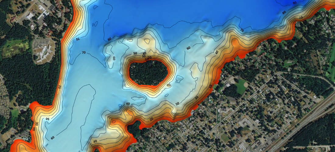
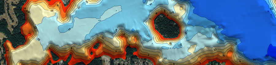
Underwater Mapping
The depth sounder on your boat can detect how deep the water underneath you is. Your GPS knows where you are. ReefMaster puts this depth and position data together to build a highly detailed underwater map.
- Create contour maps from sonar log files and view them in 2D and 3D, with a range of base-map options.
- Combine mapping data from a wide range of sources, including native Lowrance and Humminbird sonar logs, GPX files, NMEA 0183, ESRI Shapefiles and text files.
- Create maps of the sea or lake bed hardness using the optional Bottom Composition add-on module.
- Calculate water volumes using the optional Volumes and Areas add-on module.
- Create, drag and drop waypoints in both the 2D and 3D map views.
- View and export maps in a range of pre-defined palettes, or create your own colour scheme.
- Adjustable contour intervals in metric or US units.


Create maps in real-time with NMEA 0183 data:
- Log depth and position data via NMEA 0183.
- Create maps in real time, with a split screen (live-track/map) display.
- Receive GPS and depth from up to two separate NMEA sources, with adjustable latency.
- Show the live boat position on any ReefMaster screen.

Save your maps in a range of formats, including:
- Single click export for a range of Lowrance and Google Earth Preset Map Styles.
- Generate stunning AT5 vector or shaded-relief maps for Lowrance and Simrad GPS units.
- Create contour maps as track files for display on Humminbird devices.
- Export full-colour contour maps in Google Earth's KML format for display within Google Earth and mobile devices.
- Save geo-referenced, high-resolution map images for use in documents and websites.
- Save contour maps in ESRI Shapefile format and 3D bathymetry in ESRI grid format for use in other GIS applications.
Example Lowrance, Google Earth and image map exports:


Multi-channel Sonar Viewer
- Compatible with Humminbird and Lowrance sonar log files.
- Multi-channel, split-screen display with smooth playback up to 30x.
- Adjustable brightness, contrast and colour palettes.
- Create waypoints in the sonar viewer.
- Measure distance and estimate object height or depth using shadow length.
- Adjust track-point depths in the sonar viewer to correct bottom-lock errors.

Waypoint Management
- View and edit waypoints, with drag and drop in 2D and 3D.
- Import and export waypoints in a range of formats, including native Lowrance, Humminbird and GPX, with automatic duplicate elimination.
- Support for multiple waypoint sets, with easy, graphical copying and moving of waypoints across sets.
- Attach any number of notes and images to waypoints.
Track Management
- Store your past tracks in ReefMaster, with easy access via the Asset Library.
- View tracks over world base-maps.
- Crop, split and merge tracks, and save the results back to your GPS unit.
- Adjust track-point depths for lake-level or tide variations.
- Log data from NMEA data sources.
- Export raw track data in a range of formats, including comma-separated text files for use in other GIS applications.

Additional Modules
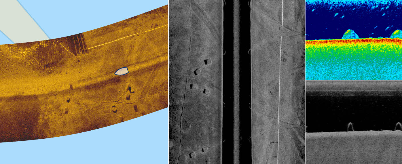
Sidescan Mosaic
Create high-resolution mosaic images from sidescan sonar logs
- Compatible with Lowrance and Humminbird sidescan sonar data.
- Combine data from any number of sonar files.
- Fast and easy review of in-situ sidescan data.
- Automatic blending of sidescan swaths to produce composite images with little or no editing.
- Noide reduction, sharpening and adjustable, across-swath gain correction.
- Export high-resolution sidescan imagery in a wide range of formats, including PNG images, Google Earth, MBTiles and Navico AT5.
Requires an existing ReefMaster license

Bottom Composition
Create hardness maps from sonar log files
- Roughness (E1), hardness (E2) and peak signal layers
- Export hardness maps as contours or iso-areas in Shapefile, KML and Navico AT5 formats
- Full vector Navico AT5 format overlays can be turned on or off via unit settings
- View hardness maps in 3D
Requires an existing ReefMaster license
Volumes and Areas
Measure mapped areas and water volumes
- Calculate water volumes across a configurable range of depths
- Calculate sediment volumes using a known reference depth
- Export measurements in CSV format for use in Microsoft Excel
Requires an existing ReefMaster license
Sonar Viewer
The ReefMaster Sonar Viewer is a Windows PC application that combines a multi-channel sonar viewer with the display of side-scan sonar over a world base map. The sonar viewer works with sonar logs from Lowrance and Humminbird units, and lets you view any combination of your available sonar channels with smooth playback at speeds of up to 30x. Waypoints can be created and edited in the sonar or map views, and loaded and saved in a variety of file formats.
Note: Lowrance users should look at our Waypoint Manager/Sonar Viewer for Lowrance application, which includes Lowrance-targeted waypoint, trail and route management features as well as a multi-channel sonar viewer.

Why use a sonar viewer application on your PC?
- More Detail
Sonar logs are typically recorded at a much higher resolution than can be displayed on even the largest units, whose screens are still small when compared to a typical PC. The ReefMaster Sonar Viewer will show your sonar logs with a level of detail that you just can’t see on the water. - Easier to use
Modern sonar units work great, but nothing beats using a computer to quickly control sonar playback, pan and zoom and for creating and editing waypoints over interesting features that you may have missed whilst on the water. - More features
The ReefMaster Sonar Viewer can do more than your unit, including displaying sidescan sonar data in the map view, measuring distances, estimating object heights from shadows and saving image snapshots. - More Convenient
Reviewing your sonar logs on a computer is a lot less hassle than going out to sit in the boat, or rigging up your fishfinder inside. Simply take the memory card out of your unit and pop it into your PC or laptop. You can store as many sonar logs as you like on your PC, and easily switch between them.
Features
- Supports Humminbird and Lowrance sonar log files.
- Multi-channel sonar viewer can display any combination of available sonar channels.
- Map view displays in-situ sidescan sonar over world base map.
- Brightness, contrast, automatic gain correction and noise reduction.
- Range of sidescan and 2D sonar colour palettes.
- Display, create and edit waypoints, with loading and saving of waypoints to a variety of file formats.
- Measure distance in the map or any sonar channel view and estimate object height or depth in the sidescan channel view.
- Save or copy image snapshots from map or sonar views.
- Metric or US units.
Easy to use and highly controllable
The ReefMaster Sonar Viewer is extremely simple to use and easy to control. Zoom in or out of the map and sonar views using the mouse wheel, "zoom-box" or pinch-to-zoom on touch-screen devices. The map or sonar positions can be moved by dragging with the mouse, even whilst the sonar is playing. Image controls such as brightness and contrast are available for each individual view panel via pop-up controls
Flexible Layout
The relative sizes of the map and sonar viewer displays can be easily adjusted by dragging any of the dividing bars, and the individual displays can be toggled on or off. View both of the displays at once, sonar only or map only.


Range of Colour Palettes for 2D and Sidescan Sonar
Work in the palette you are most comfortable with by choosing from a wide range of palettes suitable for 2D and sidescan sonar.


Measure distance and estimate object height
The ReefMaster Sonar Viewer features simple, "click and drag" distance measuring in the map and any of the sonar channel displays. In addition, the height (or depth) of objects in the sidescan sonar channel can be estimated by measuring the length of shadow.


